If you're looking to make the most of your time in lockdown, and looking for new things to do while you take your daily exercise, why not devote some time to improving your navigational skills? While the hills and mountains might be out of reach for now, you'd be surprised how much you can improve wherever you might be.
First, Learn the Key
It is useful to learn what everything is on the map and that’s a great place to start.
For example, did you know that a right of way ‘may not be clearly defined on the ground’?
Have you ever noticed the small green markings indicating rough grassland, scrub or bracken? If so, have you ever noticed that blue markings indicate marsh, reeds or saltings?
What does an electricity pylon look like and why does it matter?
Did you know the width of a river has to be greater than 8m in order for it to be shown on the map as two blue lines filled in with light blue, rather than a single blue line?
Take a moment to sit down with your maps, whack open the key, and get studying.
For easy learning, here are the keys for both 1:25 000 and 1:50 000 maps:
Improve your long-distance feature recognition and judgement of distance
Being able to judge how far away something is, or how big something is in real life is really important when out hiking.
Imagine that you have planned a journey where you will arrive at a flatter section of land along a ridgeline, as shown by the map pin in the example below. You know when you get to that part of your route, you would like to skirt around the rockier terrain to the South to make it easier going underfoot. You measure the section as being just under 100m long but when you arrive, it seems far longer.
It’s possible you’re in the wrong place. Looking back at your map, if this flatter section of land is bounded by very steep terrain immediately to the East and rockier, slightly steeper terrain to the North, and it’s 150m from the stream and field boundary to the West; you must be there.
It is also helpful if you can spot your route in the distance too so you can understand which path you will be following, where the key features are and how that might affect your journey. Do you pass under that cliff over there? Does the lower path looks boggy in a couple of kilometres? Is there an alternative?
So how can we practise this at home?
Depending on how built up the area is around your home, will depend on what approach you might take. For example, if you live in a city without local access to open spaces.
Firstly, look out of your window and make a list of a few things in the distance you can see, try and look at things that aren’t miles away!
Guess how far away they are from you.
Then go online and measure how far away they actually are from you.
For example, let’s imagine you work at the Sport England head office in London. This might be your view from the window:
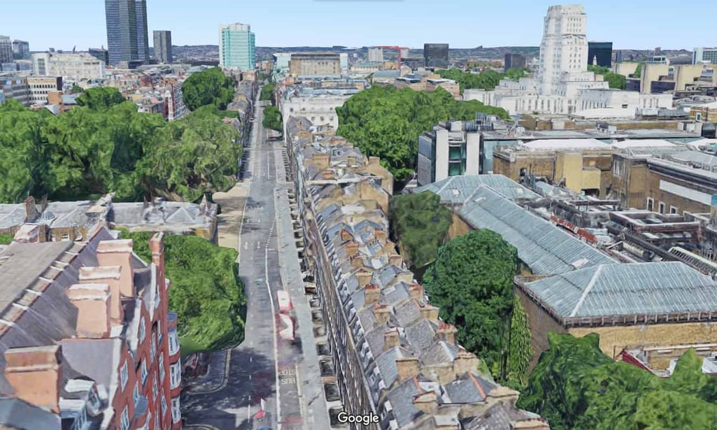
You wonder how far away that tall white building on the right is from you. How long is the park on the left? How wide is the street? How far away is that blue-green building towards the end of the road?
On Google maps you can right-click the mouse to measure distance.
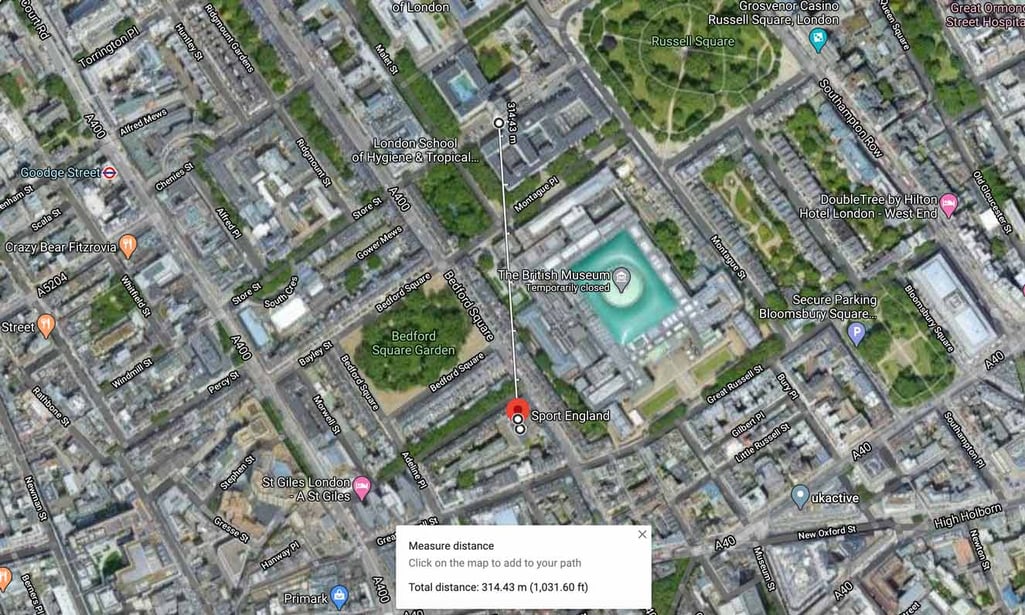
Here we can see that the white building is 314m away.
The park on the left is 100m long, the street is 14m wide, and the blue green building is 900m away.
If you live near or in lots of open space this will be easier to relate to the upland environment as you can practise with natural features as you would in the hills.
You could incorporate this into your local exercise too if you are able to get outside. When you are next out on a walk, have a look around you and practise judging distances and sizes of things. On your return home go online and check how accurate you were. If you own the OS map of the area you live in, then you can practise measuring these distances on your map with the romer on your compass. Or, if you happen to have a large garden or live on a farm you can do this in your backyard.
Work on your map memory
There are two different options here, the first is for people who are able to leave their home, and the second is for people that are currently unable to leave their home.
Plan or alter your local exercise route to go somewhere different. This could be just a small section of the route, or an entire route. If you have lots of time free you can plan the entire route in a similar way to how you might plan a walk in the hills. Consider the distance, duration, direction, description and any dangers along the route. Then, attempt to walk the entire route, or parts of the route from memory. (This will depend on how long the route you have planned is!)
Something as simple as:
Leave the office on Bloomsbury Street, head NW to the garden (the park we measured earlier). Walk the 100m across the garden to the far side, go NE towards Russell Square etc… If you can get to a park or open space, then you can practise working from natural features rather than man-made ones which will help with your contour interpretation too.
If you are not able to leave your home you can draw your own map of your house, as to scale as possible. Then you can plan a route, or better still get someone else to plan the route for you, and follow it. Whilst this sounds incredibly simple it can help with thinking about the scale of a map, orientation of the map, and memory. You could even email your map through to a friend, they can plan a route for you which you then have to follow on memory whilst video messaging them! This is also a great way to begin teaching the principles of navigation to kids.
Practise pacing and following a bearing
Pacing is the art of using your steps as a measure of how much distance you have covered. One ‘pace’ begins when your foot leaves the ground and ends when that same foot touches the ground again. With practice, you can develop an ability to pace out given distances over different types of terrain; a useful skill when visibility is poor and you can’t easily relate features on the map to what you can see.
Here are a few ideas to practise your pacing when at home (if you have a garden) or out locally:
Measure a section of path / road / terrain on the map or online before you leave the house. Then go and pace it. You could choose various places on your local walk to pace and check accuracy.
Pace 100m down a street in one direction, turn around and pace back to the start. Did you arrive in the same place?
If you have a hill or incline nearby, practise pacing up it. Practice on as many different types of terrain local to you.
In an open area, mark a start point and try pacing North for 50m, East for 50m, South for 50m, West for 50m. How close to the start do you arrive back at? This can be practiced at a distance of your choice.
With a member of your household (who can navigate too) get them to place an object out of view from you at a certain distance and along a bearing from you. You then follow that bearing and distance until you find it.
Embrace Technology
Maybe you have a GPS unit hidden away at home that you still haven’t really used yet. Dig it out, read the instructions or watch some YouTube tutorials specific to your device and have a go. Can you plan your local exercise, journey to work or the supermarket on your computer, load it into the device and follow it? Is it easier to input things directly into the device or preload them via your computer?
Have you ever tried using your phone for navigation? If not, download a navigation app such as OSmaps or Viewranger (both come with free open source mapping, or you can buy / subscribe to OS). Try planning a route on it, try following a route and recording a route. Can you get it to give you a grid reference of your location? Can you navigate to a specific point?
If you don’t own a GPS device or smartphone, try planning a route on a mapping website online. Useful ones include:
Ordnance Survey: where you will need a subscription to view OS maps, but there is an open-source map there too. You can also see things like where all of the Munros, Wainwrights and trig points in the UK are in the Menu - Places tab.
Viewranger: free to access open source maps, you can also buy or subscribe to country specific maps
Fatmap: free to access satellite imagery with options to add terrain layers enabling you to see different gradients and slope aspects. Some country-specific maps are available to members. There is also a free online guidebook covering a range of activities across the world.
Komoot: more specific to cyclists, with similar features to the above websites, however they endeavour to show paths via type on their open-source mapping. The idea being that you know what surface the path or road is likely to be.
Happy navigating!

