Understandably getting into the hills to have a Quality Mountain Day is challenging right now, but this aim of this section is to allow you to plan your future adventures and future quality days out. There are suggestions for days out, things to consider in terms of ‘themes for the day’ and there are a few ideas to get you out locally to where you live too, with some ideas of ways of staying current whilst locked in or limited to where you can travel.
During this time, I’d thoroughly recommends getting OS Maps on your computer, phone or tablet. After lockdown, if you’re not into it, cancel your subscription but for the meantime, check it out, it's brilliant. First thing is to view your local area at 1:25,000 (1:25) scale. Hopefully, by now you are also familiar with Mountain Training’s candidate handbook, you’ve read to from cover to cover and paid attention to the appendix at the back which is where the definition of a quality mountain days lies. We discussed in the last section that its beneficial that you evidence a logbook a variety of experiences in a number of mountainous locations, and that the breadth of experience you gain from this variety stands only to benefit you and your confidence in the mountains. You’ve had the chance to reflect and scrutinise your logbook, now the planning starts.
What was your feedback from your training course? Did you have any areas to work on? If you can’t fully remember your debriefing, don’t worry. Pay attention to each area of the syllabus, digest Steve Long’s Hillwalking book, use Mountain Training’s skills checklist and structure your practice sessions now. Allow enough time to rehearse all the skills so they are demonstrated confidently on your assessment. It’s all about maximising your days out and getting the right practice in. And it can start here. Let’s start with navigation.
The assessment’s not all about “micro nav”. It’s not all about staring at a 1:25 map and travelling small distances between tiny features. We might travel small distances to large features, large distances to small features, whatever’s appropriate given the day. It’s worthwhile understanding the differences in scales how they lend themselves to different ways in which we navigate. Over the assessment, we will endeavour to spend time on 1:25 and 1:50 maps and incorporate 1:40 maps for further development if candidates have limited experience. It can often be the larger scales which get overlooked. The differences between Harveys maps and Ordnance Survey are quite distinctive. With this in mind, setting a theme for the day in terms of what navigation practise to focus on is a really wise move. It might just be spending the day or a number of days on a 1:50 map. You might be in Scotland. What are the pro’s and con’s if you’re not familiar with that scale? A common problem found when going out practising for an assessment is sometimes trying to do too much too early on. For example, you should’ve found over the training course, the trainer would’ve included new or different pieces of navigation each day. Each day building on the previous, so that culminating 2-day mini-break, with loads of nav in the day and at night was all in context and felt like a nice learning progression. So adopt a similar approach to your own practice. What did you cover on day 1? Did you cover planning & building navigation strategies? You might use 3 Whats maybe even 4 or 5 Ds? Building a picture of your journey before you set off.
3 Whats
- What will you see on the way?
- What will you see when you get there?
- What will you see if you go too far?
5 Ds
- (Danger)
- Direction
- Distance
- Duration
- Description
Whether you see yourself as ok but in need of some practise or super slick, go over the basics, you will get skill fade otherwise. Day or night, summer or winter if you have a consistent approach to your navigation then you will feel confident. Practise individual skills before performing them all at once. It’s the process of skill acquisition. Can you remember how your trainer introduced different navigation skills? Did you get information overload from orientation to slope aspect assessment straight away? Which navigational skills lend themselves better to certain situations? What dictates whether you need to be really detailed or less so? Visibility, weather, objective dangers, consequential outcomes, familiarity perhaps? Remember the point of being able to create a map memory is so that you can navigate concurrently whilst leading groups, allowing you to educate them & keeping them safe.
 OS 1:25 View
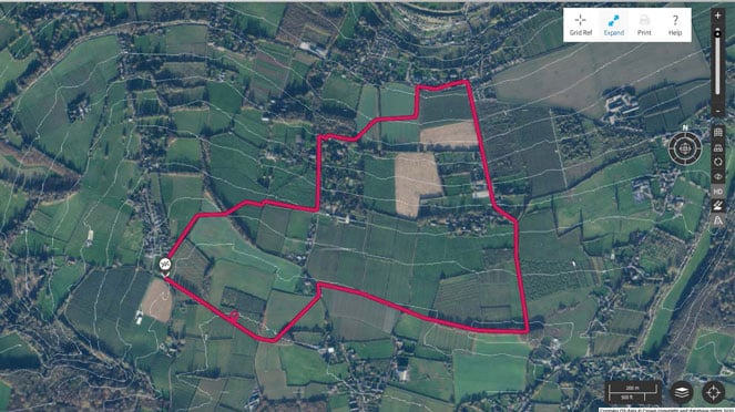
Aerial 3D View Showing 5m contours
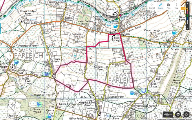
You can rehearse this on a local walk to where you live. So how can you practise this at home under the current lockdown measures? This is where your interaction with digital mapping is the way forward. This is also the chance for a reminder what are your access rights for walking in your local area? Are you venturing on to open access or private land? What does CROW stand for, what does the Mass Trespass have to do with walking in Kent? If you’ve forgotten it might be worthwhile reading up first. The above map shows a 5km loop taking in footpaths across private farmland (the GPX file is here). On this loop, you could practise timings, pacing, bearings for example. It’s about being creative. Can you identify an area within a short distance from you where you could do something similar? A great way to practise is to go out with a friend or partner, or someone from the same household. Take them with you and teach them the skills that you are practising. It gives you some company and it allows you to break the skill down into smaller pieces for learning, reinforcing your own understanding of the skill. How often do you use the ruler for measuring or do you just use the roamer? Do you know how far 1mm equates to? A super useful skill, particularly for micro nav, particularly at night…
 Do a pacing exercise near you
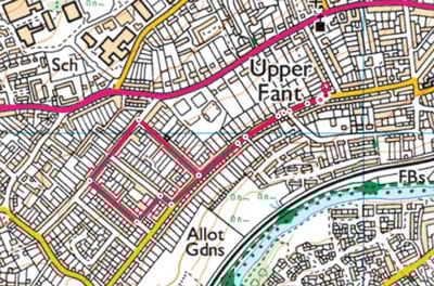
Find your place of residence on 1:25 scale map and plot yourself a small circuit, plotting waypoints at road junctions, alleys etc. Take note of the distances between the waypoints. When’s the last time you left the house?! Hopefully, you still know your pace count for 100m, if not you could always use OS Maps to find somewhere near you that is 100m, between road junctions for example. Try doing it this wearing your walking boots too. You’ll have a different gait walking in trainers, nice time to dust them off. Have you calculated how many steps you take for 50m, 25m,10m, 5 etc? It’s useful to know and learn. Jot these down somewhere until you’ve learnt them, there’s no test but it can be easier if you can quickly refer to the numbers. As a progression, after doing a loop similar to the above, extend it, pace down streets without any knowledge of how long they are and then refer back to digital mapping afterwards for confirmation. How close was your pacing? GPS watches and fitness trackers have ways to measure distance so they can be handy too.
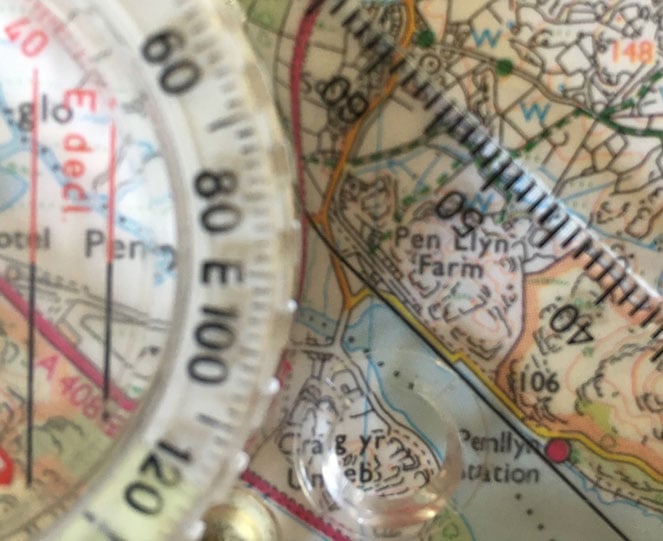 The edge or the black line - which do you prefer?
You could use this time to remind yourself how to take a bearing too. Although it’s probably easier to take them from a paper map. You could use your phone screen, but magnetic fields could affect your compass needle. Be warned. People often ask if there’s an issue using either the black line on the base plate or the edge of the compass, and the reply is no. However, at night in the rain, moisture droplets and head torch light can sometimes cause light refraction on the 2mm edge of the compass and may lead to slightly inaccurate bearing measurements. Overlapping the black line can avoid this. Remember you don’t have to use every navigational tool all the time. But using more than one in conjunction with another does bring about good results. What were the influencing factors again? Can you see, are there objective dangers that need careful boxing around? Bluebird days generally don’t need a compass to tell you what direction to walk. So, what to practise instead? Here are a few themes for a day.
- How about not using the compass for anything other than measuring? Focus the day on orientation, orientating the map every time you stop and working out an intended journey from that
- Focus the day on timings, how does Naismith’s rule apply under what circumstances? 30/60 seconds per contour, does it differ between close/spaced contours?
- Focus the day walking to contour features that you can visually recognise in the distance and identify on the map. In doing this you can develop strengths in contour interpretation.
- Spend time ‘off paths’ on each scale map. If time allows all day, or maybe just on the way up/down
Footpaths and bridleways are great ways to explore areas, but your navigation must focus on time spent off paths. Paying particular attention to not damaging flora and fauna is of the utmost importance but over the course of the assessment, you will spend very little time walking on way paths, so it is critical that you spend a sufficient amount of time away from them. This means that we must spend time in open access land, which currently we may have restrictions imposed on us particularly in national parks.
Open access land isn’t necessarily in the mountains, contour lines, features, spurs, re-entrants are everywhere! Search our your nearest C.R.O.W. land and think how you could utilise that area for some practice.
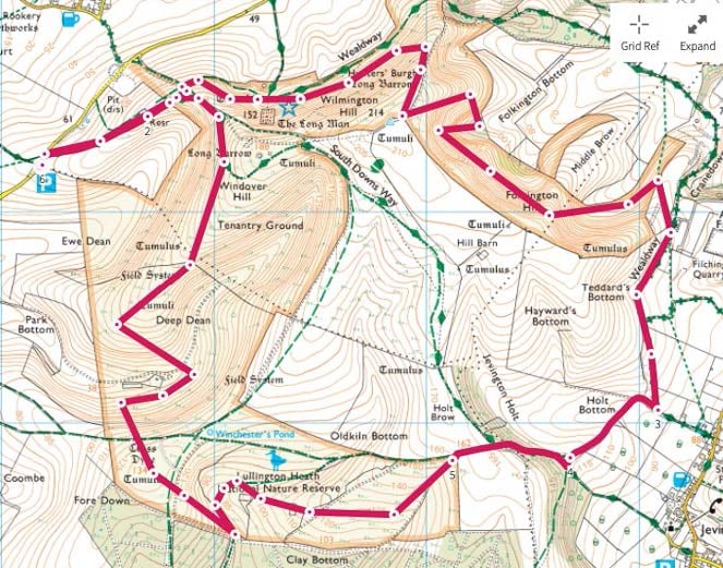 Linking open access land with footpaths and bridleways on the South Downs.
The GPX file for this micro nav loop is here.
Practising alone can be quite demoralising, especially when the weather’s bad, these are times when some type 2 fun might be the order of the day and bribery may be in order to have company. The Mountain Training Association and social media groups are a great way of networking and making contacts who may be in a similar boat as you. This can be particularly useful taking it in turns to lead a leg each (this can also be done locally!), selecting each other’s legs and looking after each other as necessary. Alternatively, simulate the assessment and don’t tell them where you are going for a leg or two, and then allow for relocation practice. If you are struggling to find a like-minded candidate to practise with, do you know any already assessed Mountain Leaders who can give you a series of legs to find (they could even send you a GPX file,) and by transferring the points onto a paper map, put your phone away and go seek out each point, only using your phone for confirmation? Remember when using your mobile device outdoors, the batteries are susceptible to dying a bit quicker in the cold. Mapping applications can speed this up. Having a power cell for the event of an emergency might be useful.
You can extend your practice into a bit of teaching, by going off with an inexperienced partner. A fun game is where you identify your location, explain where you’re heading, direction, summit etc. and ask them to choose a feature to go to. Depending how brave you are feeling you can just hold the map out and ask them to place a finger or maybe guide them in what might seem a logical place to head. Your call. Talk through your strategy with them, explaining why you are doing it etc. pass on your knowledge like you hope to do in the future. This might lead nicely into some management during the journey, again super useful time spent off the path. Do you know any more flora or fauna to spot? A different one or two from the last time is achievable. Not every day is and must be a quality mountain day. Not every day has to be off the paths either. Sometimes the journey is what is the goal, a big day, you start early, and you get down late, you’ve really earnt your pint or two. Remember the criteria mention in Mountain Training’s literature. It’s easy to overlook some of the finer detail, now with DLog you can separate your quality days with regular mountain days.
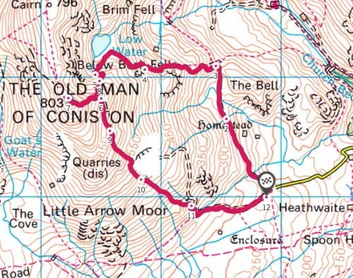 A mountain day (GPX File Here)
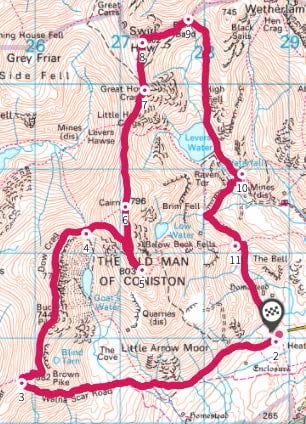 A quality mountain day (GPX File Here)
Was there any terminology you had difficulty remembering? Spurs or ridges, re-entrants or valleys for example. What’s a knoll? Steve Long’s Hillwalking book might help.
 How many different features can you identify?
Planning Exercise
Plan a day out using OS Maps/Viewranger on the computer is to pick a mountain you’ve not been up yet. Plot a journey up and down taking in as many different features as is logically possible. If there happens to be a wall or a sheepfold en route, great, use those too. Remember, things can and will go wrong, it’s all part of the learning. It’s useful to review each day, what were the key learning points or what didn’t work and why. Don’t be afraid of asking a question, we’re only at the end of an email. It’s all about getting the faff out the way before the assessment by practising everything methodically and reinforcing your confidence.
At the end of this section, you should have a list of mountains that you have been up (your logbook) and a list of areas you haven’t been to yet (your wishlist). The intention of this section is that you plan a list of days/trips now, research the area and familiarise yourself with the journey, to give you some psyche for when we’re fully allowed back into the mountains.

